The Group on Earth Observations Global Agricultural Monitoring (GEOGLAM) and the Agricultural Market Information System (AMIS) are spinoffs of the 2011 G20 Summit. GEO provides earth observation (EO) datasets from its members to AMIS’s GEOGLAM initiative for enhancing global food market transparency and food security policies. The G20 can recommend GEO integrate data from commercial EO entities, including those monitoring emerging biophysical and socio-econo-political risks for GEOGLAM. It can direct AMIS to provide crop monitoring and early warning datasets for more than four staple crops. Moreover, it can encourage GEOGLAM to pursue satellite-based crop monitoring of small-acre farms.
Challenge
The Group of 20 (G20) has long recognized the need for global actions to enhance and sustain agricultural productivity and strengthen food security. The G20 Agriculture Minister’s Action Plan 2017 [1] stated its intent to advance information-communications technology (ICT) innovation and application via public and private research and development (R&D) in the agriculture sector. The R&D pursuits include:
- Striving for precision agriculture;
- Using analytics and big data; and
- Enabling farmers to utilize precision agriculture techniques to improve farm productivity and make their operations sustainable.
To that end, the Agriculture Monitoring Information System (AMIS), placed within the ambit of the Food and Agriculture Organization (FAO) of the United Nations, has been running the Group on Earth Observations Global Agricultural Monitoring (GEOGLAM) initiative to monitor crops from food market transparency and food security standpoint, in partnership with the Group on Earth Observations (GEO). Despite a well-functioning GEOGLAM initiative, the current use of satellite-based EO data for attaining G20’s agriculture-related global actions is minimal.
The existing configuration of the GEOGLAM initiative under the aegis of AMIS is limited to monitoring only four staple crops – wheat, rice, maize, and soybean. GEOGLAM, to a lesser extent, monitors crops like sorghum, millets, beans, and teff, through the assistance of the World Meteorological Organization, but only for early warning indicators in non-AMIS member nations, particularly those in Eastern Africa’s Intergovernmental Authority on Development (IGAD) multilateral [2]. Keeping EO-based agricultural monitoring limited to a few crops contributes inadequately to the global food security challenges.
Another limitation with the current configuration of GEOGLAM is its inability to provide crop monitoring and early warning from EO data products to small acre farms, which are common in both developing and developed economies globally. Current global-scale satellite-based agricultural monitoring is carried out with low imagery spatial resolution of up to 30 m [3]. The GEOGLAM initiative needs high spatial and temporal resolution EO datasets to address this challenge. Commercial EO companies operating satellite constellations are generating high spatial and temporal resolution and hyperspectral end-user-ready EO datasets and data products [4].
The Group on Earth Observations (GEO), the intergovernmental organization supplying EO data to GEOGLAM, has recently begun interacting with commercial EO entities. Present-day commercial small-satellite constellations are beginning to offer end-user-ready EO data products by developing downstream data-processing abilities. These abilities are fostering end-user readiness in farmers and agriculture-allied businesses. GEOGLAM is yet to formulate concrete policies to increasingly utilize state-of-the-art, high spatial (<10 meter) and temporal resolution, granular (hyperspectral) datasets and products from such commercial EO satellite constellations for crop monitoring. GEOGLAM’s data gathering processes need reforms for enhancing and sustaining agricultural productivity and strengthening food security.
Proposal
In 2011, the G20 Agriculture Ministers launched the AMIS satellite-based crop monitoring platform under the aegis of FAO. The AMIS’ task is to assess the global food supplies and coordinate policy actions related to global food security. AMIS’ participants are the G20 nations, Spain (permanently invited to G20), some European Union member nations, and some other invited nations from across the world (refer to Table 1). Together, AMIS participants constitute almost 80-90% of total global agricultural production, consumption, and trade of the crops.
Table 1 Participants of the Agricultural Monitoring Information System
| AMIS Participants from G20 | AMIS Participants from EU | Other Invited AMIS participants |
| Argentina | Austria | Egypt |
| Australia | Belgium | Kazakhstan |
| Brazil | Bulgaria | Nigeria |
| Canada | Croatia | Philippines |
| China | Cyprus | Thailand |
| France | Czechia | Ukraine |
| Germany | Denmark | Vietnam |
| India | Estonia | |
| Indonesia | Finland | |
| Italy | Greece | |
| Japan | Hungary | |
| Mexico | Ireland | |
| Russia | Latvia | |
| Saudi Arabia | Lithuania | |
| South Africa | Luxembourg | |
| South Korea | Malta | |
| Turkey | Netherlands | |
| United Kingdom | Poland | |
| United States | Portugal | |
| European Union | Romania | |
| Spain (Permanently Invited) | Slovakia | |
| Slovenia | ||
| Sweden |
AMIS functions via three internal arms: the Global Food Market Information Group, the Rapid Response Forum, and the Secretariat. The Group provides accurate, comparable, reliable, timely agriculture market and policy information. The Forum discusses critical agricultural market conditions and suggests mitigatory solutions. The Secretariat generates short-term global agricultural market assessments, analyses, and outlooks. AMIS closely monitors other indirect indicators – dollar indices, ethanol prices, oil prices, fertilizer prices, and ocean freight prices – directly affecting global food pricing and security [3].
To address the G20 Action Plan on Food Price Volatility, the 2011 G20 Ministers of Agriculture meeting, along with AMIS, had launched the GEOGLAM initiative. GEOGLAM is a flagship initiative of the intergovernmental GEO organization, which currently has 113 member governments, 140 participating organizations, and eight organizations with observer status. GEOGLAM aims to enhance the use of EO for formulating global food security and sustainable agriculture, strengthening decisiveness, and taking informed actions.
Over the last decade, GEOGLAM has been curating a global Crop Monitor for AMIS, regularly providing global EO data products on wheat, rice, maize, and soybean crop conditions. The data products include cropland masks, crop conditions, crop-type maps, soil moisture, temperature, evapotranspiration, rainfall, and crop yield forecasts [5]. GEOGLAM integrates EO information building block indicators representing state and change of phenomena called ‘essential agriculture variables’ [6] to develop these data products. These EAVs are gathered from various EO satellites and integrated via a community-driven data processing exercise. Here, the 44 partners of GEOGLAM contribute profusely to the Crop Monitor initiative (refer to Table 2), which curates monthly reports for AMIS and Crop Monitoring for Early Warning (CM4EW) reports for many non-AMIS nations vulnerable to food security challenges [7]. In the case of CM4EW, GEOGLAM monitors sorghum, millet, teff, and beans beyond the four staple crops that AMIS is monitoring. However, the CM4EW is currently limited only to a few regions of Africa.
Table 2 G20 and non-G20 partners of GEOGLAM’s Crop Monitor initiative
| G20 Members | G20 Partners in Crop Monitor Initiative | Multilateral Organizations and non-G20 nations | Multilateral Organizations and Non-G20 partners in Crop Monitor Initiative |
| Argentina |
| ASEAN |
|
| Australia |
| Asia-RiCE Crop Estimation and Monitoring (Asia-RiCE) | |
| Brazil |
| International Maize and Wheat Improvement Center (CIMMYT) | |
| Canada | Agriculture and Agrifood Canada | Food and Agriculture Organization of the United Nations | FAO Global Information and Early Warning System |
| China | Chinese Academy of Sciences | Group on Earth Observations (GEO) | |
| France | GEO Global Agricultural Monitoring (GEOGLAM) | ||
| Germany | GeoTerra Image | ||
| India |
| Thailand |
|
| Indonesia |
| Gro Intelligence | |
| Italy | Earth Data for Informed Agricultural Decisions (HARVEST) | ||
| Japan |
| Austria | International Institute for Applied Systems Analysis |
| Mexico | Agrifood and Fisheries Information Service | International Food Policy Research Institute | |
| Russia | Space Research Institute (IKI) | International Rice Research Institute | |
| Saudi Arabia | Vietnam |
| |
| South Africa |
| Ukraine |
|
| South Korea | Kazakhstan | National Hydrometeorological Service of Kazakhstan (RSE KAZHYDROMET) | |
| Turkey | Asian Development Bank (ADB) | Greater Mekong Subregion Satellite-based Agriculture Support System | |
| United Kingdom | Uganda | Office of the Prime Minister | |
| United States |
| Monitoring for Environment and Security in Africa (MESA) | |
| European Union | EU Science Hub – European Commission Joint Research Centre | World Food Programme | |
| Spain (Permanently Invited) | Tanzania | Ministry of Agriculture, Livestock, and Fisheries | |
| Intergovernmental Authority on Development | Climate Prediction and Applications Centre | ||
| Applied Geosolutions |
I. Enhance GEOGLAM’s Monitoring Capabilities from the currently limited focus on staple crops
The gap in the global production of staple cereal crops and the volume of these crops consumed by humans has been widening for decades [8]. In a 2014 FAO study, the maize crop was known to have the highest production surplus overconsumption, around 57%, followed by wheat surplus at 18%, and rice surplus at 8%. Of these surpluses, almost 60% goes for animal feed, a third for industrial usage, including biofuels, and the rest goes into stocks [9]. Two of the four focus staple crops of GEOGLAM are increasingly being used for non-food applications [10] and therefore are not entirely central to the mandate of GEOGLAM and AMIS. Therefore, GEOGLAM and AMIS should diversify their Crop Monitor initiative and redefine agriculture yield from measuring it in tonnage to per capita nourishment per hectare [11].
The Matera Declaration on Food Security, Nutrition, and Food Systems was released during the G20 Foreign Affairs and Development Ministers Meeting held under Italy’s Presidency in 2021 [12]. Providing adequate nutrition for all has become an agenda synonymous with food security with the Matera Declaration. Furthermore, the declaration endorses the commitments made during the UN Decade of Action on Nutrition, the Scaling Up Nutrition Movement, the Nutrition for Growth summits, and the Sustainable Development Goal (SDG) 2 that states “ending hunger in all its forms”.
The GEOGLAM, too, is preparing to develop quantified metrics on three contemporary and major global policy drivers – the Sendai Framework on Disaster Risk Reduction, the Paris Accord on Climate Change, and the UN Sustainable Development Goals (SDG) [13]. Given the GEOGLAM’s commitment to SDGs, the GEOGLAM is obliged to adhere to SDG-2 and the G20’s recent Matera Declaration. However, such a pledge needs to be clearly stated. This policy brief states that the G20, in consultation with AMIS and GEO, should consider expanding the food security ambit of GEOGLAM to food and nutrition security. This new ambit can be exercised by mandating GEOGLAM to solicit research and development (R&D) on EAV for regional crops beyond the existing four current staple crops. This R&D can be solicited to the Joint Experiment for Crop Assessment and Monitoring (JECAM) [14], another extant GEO initiative.
II. Bring private satellite companies and downstream data companies into GEOGLAM’s ambit.
The GEOGLAM gathers satellite data – classified from analysis-ready (level-3) to raw (level 0) – from EO satellites operated by governmental space agencies and space research institutions, especially the members of GEO and Committee on Earth Observation Satellites (CEOS). GEOGLAM then curates EAVs from the gathered data for AMIS and CM4EW. The data products then proceed to end-users like agricultural markets, early warning agencies, SDG, Paris Accord, and Sendai Framework implementing entities [15]. GEOGLAM has yet to establish mechanisms to gather EO data from private sector-operated satellite constellations in their data-to-decision-making pathway (refer to Figure 1).
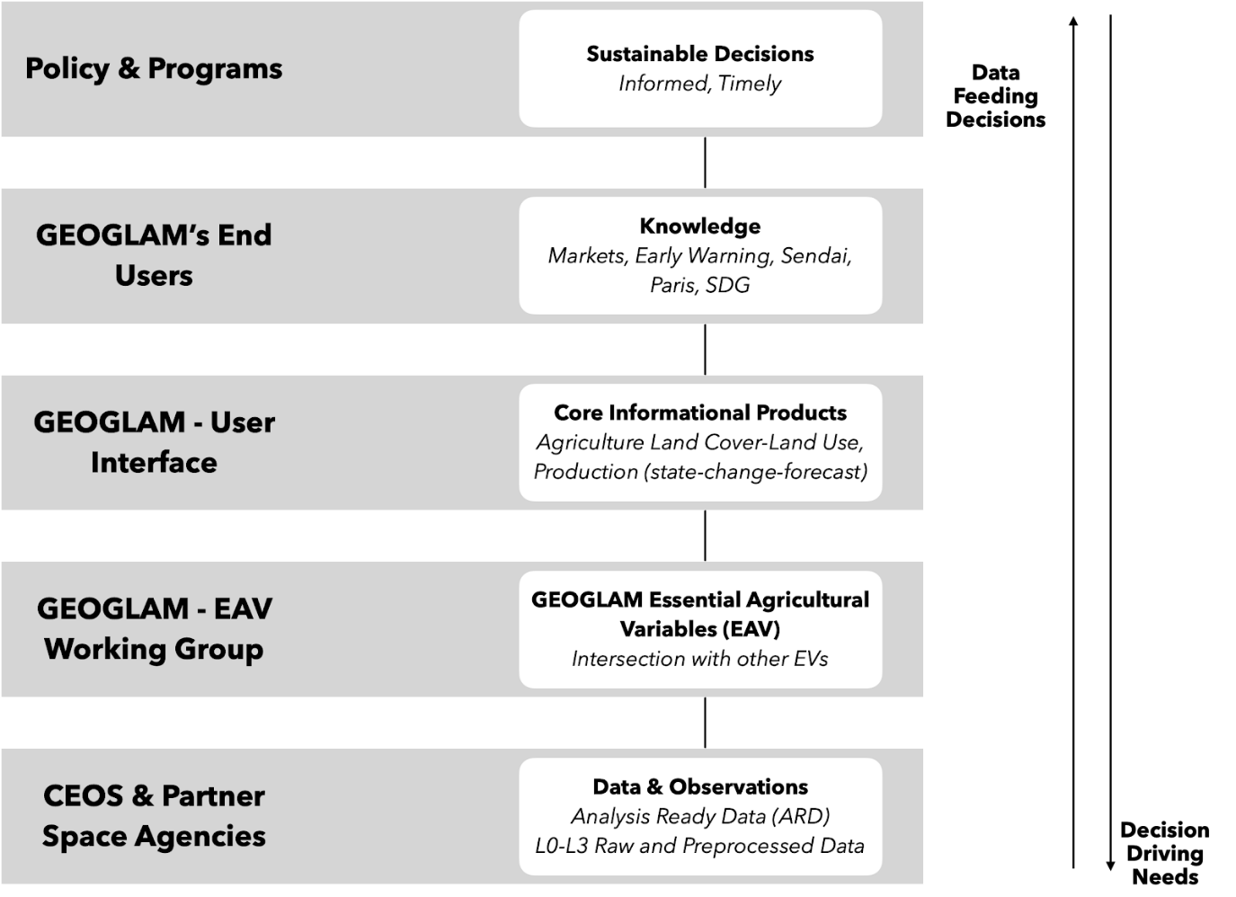
Figure 1 Data (source) to Decision (end-user) Pathway of the GEOGLAM initiative [15]
GEOGLAM can consider commercial small-satellite constellations as new and cutting-edge sources of EO data products. Commercial EO data products come with streamlined downstream processes – advanced digital data collection, cloud computing, machine learning, and artificial intelligence tools – all vital for end-users creating data products at weekly or lesser intervals. Frequently available data products can assist end-users with reports that can help them make tactical decisions, especially during wars, disasters, pandemics, and other black swan events. Such frequent reports will be of better utility for tactical decision-making than the fortnightly CM4EW or monthly AMIS reports.
New commercial EO entities are developing data products that help in monitoring biophysical and socio-political risk factors. The biophysical risk factors include delayed planting, temperature and rainfall variations, and cropping conditions anomalies. The socio-political risk factors include conflicts, irrigation infrastructure manipulation, and others. Such risk-assessing EO data products can be vital for end-users of GEOGLAM.
Despite the GEO’s vast memberships, GEOGLAM is yet to utilize commercially-ready high-resolution EO data products gathered from commercial entities for crop monitoring. The GEO has proactively begun to interact with commercial EO companies. During the GEO Week 2019 Ministerial Summit in Australia, the GEO invited numerous commercial EO companies to discuss public-private partnerships [16].
III. Emphasize GEOGLAM to monitor Small Acre Farms
The quantum of EO data used to increase agricultural productivity is currently low [17]. The issue lies mainly in the data-generation side. Lack of data products generated from high-resolution (spatial and temporal), granular (hyperspectral) satellite data for an agricultural use case perspective has distanced small acre farms [18] – prominent among developing economies – from reaping the benefits of EO data to increase agricultural productivity, upkeep food security, and attain global SDGs, Sendai Framework and Paris Accord objectives.
High-resolution and hyperspectral EO data from commercially-operated satellite constellations are beginning to cater to a new set of end-users [19] – farmers, crop insurance companies, logistics, and supply chains. Commercial satellite entities are developing functional downstream data-processing abilities and fostering end-user readiness across farmers and allied businesses. These last-mile end-users are most likely to demand user-ready data products to help them monitor the impact of climate change on standing crops, cultivate crops suitable for globalized trade and optimize agriculture value chains. The high-resolution and hyperspectral data products of these commercial entities are also beginning to supply the monitoring demands of the neglected small-acre farms. Such services will be vital for both developed and developing economies to increase agricultural productivity of small-acre farms, strengthen food security, encourage sustainable- and nutrition farming, and assist in attaining SDGs. To that end, the G20 can mandate GEOGLAM to formulate data-sharing and -management principles for such commercial EO entities and incentivize them to join agriculture-related global actions of G20 and SDGs voluntarily.
The GEO, well recognized by the G20, has advocated the humanitarian benefits of sharing data, knowledge, information, products, and services from Earth observations. To that end, the GEO formulated ‘Data Sharing Principles’ between 2005 and 2015, which motivated many member nations and organizations to get over their restricted data policies to an open data approach. GEO is implementing a new set of Data Sharing Principles, promoting ‘Open Data by Default’ [20]. Open data can, in principle, provide public access, address transparency, and relinquish data ownership. Such shared EO data, gathered from various sources and of diverse technical specifications, can be offered to GEOGLAM.
Another possible mechanism for GEOGLAM to emulate is the Commercial Smallsat Data Acquisition (CDSA) Program conceptualized by NASA’s Earth Science Division. The CDSA was established in 2017 to ascertain, evaluate, and acquire data from commercial EO entities to attain US’s socio-scientific goals [21]. National space agencies of other G20 nations can consider adopting similar public-private EO data sharing synergies by partnering with commercial EO entities in their respective jurisdictions. Such shared EO data will give business sustenance to commercial EO entities, fulfil the national socio-scientific mandate, and via the space agencies-GEO route, and bring cutting-edge and high-resolution EO datasets to small acre farms for better decision-making.
IV. Conclusion
The G20 has been central to the establishment of the GEOGLAM. Over the years, the GEOGLAM platform has attained maturity in monitoring four staple crops under AMIS’s management. However, agricultural productivity and trade are facing growing risks due to climate change and socio-econo-political events. Therefore additional mechanisms to manage nutrition security, food security, and food-feed balance are becoming necessary. GEOGLAM, endorsed by the G20, is a successful initiative. In order to attend to the emerging risks, this policy brief proposes the G20 to make the following revisions in the GEOGLAM initiative:
- G20 can direct AMIS to use GEOGLAM for monitoring global agricultural productivity and food security for more than four staple crops it currently monitors.
- G20 can recommend GEO gather EO data, information, knowledge, product, and services from private EO companies on four and more staple crops for GEOGLAM’s end-users. This recommendation aligns with GEO’s ‘Open Data by Default’ policy and advocacy for the humanitarian benefits of sharing EO data, knowledge, information, products, and services.
- G20 can encourage GEO to facilitate the supply of diverse types of EO datasets, including those monitoring biophysical and socio-econo-political risk factors generated by private small-satellite EO constellations, to GEOGLAM for its core mandate of monitoring global
agricultural productivity and food security.
- G20 can also encourage GEO to gather high-resolution and hyperspectral EO data products from private small-satellite constellations to develop cutting-edge crop monitoring solutions for small-acre farms
References
“G20 Agriculture Ministers’ Action Plan 2017: Towards Food and Water Security – Fostering Sustainability, Advancing Innovation”, Berlin, 22 January 2017, https://www.g20germany.de/Content/DE/_Anlagen/G7_G20/2017-01-22-g20-agarminister-aktionsplan-en___blob=publicationFile&v=1.pdf
Becker-Reshef, I., Justice, C., Barker, B., Humber, M., Rembold, F., Bonifacio, R., Zappacosta, M., Budde, M., Magadzire, T., Shitote, C., Pound, J., Constantino, A., Nakalembe, C., Mwangi, K., Sobue, S., Newby, T., Whitcraft, A., Jarvis, I., Verdin, J., 2020. Strengthening agricultural decisions in countries at risk of food security: The GEOGLAM Crop Monitor for Early Warning. Remote Sens. Environ. 237, 111553.
Whitcraft, A.K., Becker-Reshef, I., Justice, C.O., Gifford, L., Kavvada, A., Jarvis, I., 2019. No pixel left behind: Toward integrating earth observations for agriculture into the united nations sustainable development goals framework. Remote Sens. Environ. 235, 111470
https://www.sciencedirect.com/science/article/pii/S0034425719304894
Sadeh, Y., Zhu, X., Dunkerley, D., Walker, J.P., Zhang, Y., Rozenstein, O., Manivasagam, V.S., Chenu, K. 2021. Fusion of Sentinel-2 and PlanetScope time-series data into daily 3 m surface reflectance and wheat LAI monitoring. Int. J. Appl. Earth Obs. Geoinf. 96, 102260.
“Progress on GEOGLAM Implementation: First steps towards Implementation 2013-14 Phase I and Phase II” Group on Earth Observations, 28th Executive Committee, 16-17 July 2013, https://www.earthobservations.org/documents/geoglam/GEOGLAM_Implementation_Plan.pdf
GEOGLAM, 2019. Essential Agricultural Variables for GEOGLAM – White Paper. pp. 1–7, http://www.amis-outlook.org/amis-monitoring.
Crop Monitor: A GEOGLAM Initiative website, https://cropmonitor.org/index.php/about/amis-partners-cm/
Pingali, P., 2015. Agricultural policy and nutrition outcomes – getting beyond the preoccupation with staple grains. Food Security 7, 583-591. https://link.springer.com/article/10.1007/s12571-015-0461-x#ref-CR19
FAO. (2014). FAO Food Outlook 2014. Rome: Food and Agriculture Organization of the United Nations.
Grote, U., Fasse, A., Nguyen, T.T., Erenstein, O., 2021. Food security and the dynamics of wheat and maize value chains in Africa and Asia. Front. Sustain. Food Syst., https://www.frontiersin.org/articles/10.3389/fsufs.2020.617009/full
Cassidy, E.S., West, P.C., Gerber, J.S., Foley, J.A., 2013. Redefining agricultural yields: from tonnes to people nourished per hectare. Environ. Res. Lett. 8, 034015. https://iopscience.iop.org/article/10.1088/1748-9326/8/3/034015/pdf
“Matera Declaration on Food Security, Nutrition and Food Systems. A Call to Action in the time of the COVID-19 pandemic and beyond” G20 Italy, 2021, http://www.g20.utoronto.ca/2021/Matera-Declaration.pdf
GEOGLAM: Global Agricultural Monitoring website, https://earthobservations.org/geoglam.php
Joint Experiment for Crop Assessment and Monitoring (JECAM) website, http://jecam.org/background/
GEOGLAM: Global Agricultural Monitoring website, https://earthobservations.org/geoglam.php?t=eo_data_coordination&s1=eodc_about
GEO Week 2019 Ministerial Summit website, https://www.earthobservations.org/geoweek19.php?t=programme
Khanal, S., Kushal, K.C., Fulton, J.P., Shearer, S., Ozkan, E., 2020. Remote Sensing in Agriculture—Accomplishments, Limitations, and Opportunities. Remote Sens. 12(22), 3783. https://www.mdpi.com/2072-4292/12/22/3783
Schimmelpfennig, D., Lowenberg-DeBoer, J., 2020. Farm Types and Precision Agriculture Adoption: Crops, Regions, Soil Variability, and Farm Size. Global Institute for Agri-Tech Economics, Working Paper 01-20, https://papers.ssrn.com/sol3/papers.cfm?abstract_id=3689311
“EOS Data Analytics to Launch the first Agriculture-Focused Satellite Constellation by 2025” Earth Observation System, 18 February 2021, https://eos.com/blog/eos-data-analytics-to-launch-the-first-agriculture-focused-satellite-constellation-by-2025/
“GEO Strategic Plan 2016-2025: Implementing GEOSS” Group on Earth Observations, 2016, https://earthobservations.org/documents/open_eo_data/GEO_Strategic_Plan_2016_2025_Implementing_GEOSS.pdf
Cassidy, E. “Commercial Satellites Shed Light on Small Scale Agriculture” 22 October 2020, NASA Earth Data website, https://earthdata.nasa.gov/learn/articles/csda-small-scale-agriculture